
East Carolina University 2008 Fall Field School Findings Gallery

Mapping the Abandoned Watercraft of Meyers Wharf
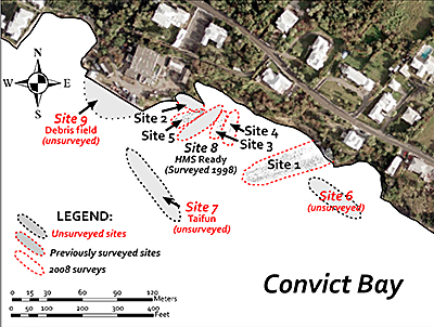
Overview of the Convict Bay Ships Graveyard at Meyers Wharf showing a synopsis of maritime archaeological survey activities. (Courtesy of Program in Maritime Studies, ECU, background image thanks to Department of Conservation Services).
East Carolina Universitys Program in Maritime Studies recorded at least five submerged watercraft in the vicinity of Meyers Wharf. One of the primary purposes for surveying and measuring the sunken vessels is to create drawings for each vessel. These maps are illustrated aerial views of the old ships as they lie on the bottom of the bay. Prior to any fieldwork conducted, archaeologists selected a 1=2 scale as the appropriate size for completed drawings. Careful attention and meticulous detail are imperative when constructing a site map in order to maintain a high level of accuracy. Upon completion these plans serve a variety of functions ranging from site description to vessel identification, all of which are vital parts of further research processes.
Next