Vietnam Maritime Archaeology Project Center
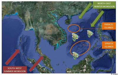
Sketch map of Vietnam, showing the directions of the monsoon, waterways, typhoons and the Paracel and Spratly islands. (map by Charlotte Pham © C.M.H. Pham). View larger version here.
Introduction
For foreign ship captains and their weary crew, the South China Sea was a treacherous body of water to traverse. Their voyages were largely dictated by the monsoon and trade winds. Navigators would have to carefully negotiate the unpredictable sea, which was dotted with shoals and reefs, and shaped by strong currents and typhoons that suddenly could drive waves to heights of 3-4 metres. On their voyages between China, the Malay Peninsula, India and beyond, local and foreign sailing ships hugged the coast of central Vietnam. This was not only to avoid the dangers associated with the open sea, but also to careen, repair or take on potable water. Harbours and anchorage points located every 10-20 km along the coast and numerous offshore islands that provided shelter and fresh water made Cochinchina ideal for stopovers. Its particular geographical location favoured trade and attracted ships and goods as well as cosmopolitan cross-cultural crowds who settled in harbours like Hoi An, Nuoc Man or Phan Rang, waiting for the reverse monsoon winds for their homeward bound journeys. The Cham (2nd-19th centuries), and later the Nguyen lords (16th century onwards), certainly knew how to benefit best from their blessed maritime environment. Although maritime related events (like shipwrecks and naval battles), maritime livelihood sources (like fishing, procuring sea-swallow nests and collecting trepang), coastal transportation and inter-regional trade were all common to the daily lives of the Cham and Cochinchinese, these are rarely addressed in Vietnamese history.
Despite a growing literature on maritime trade, shipping and navigation on the South China Sea we do not know much about how local society negotiated their maritime environment: how they benefited from their coastal location on the major trade routes or how it influenced daily life and shaped events and state development. Little is also known about local methods and skills in seafaring, boatbuilding and navigation, nor about the many harbours that dotted the coast of central Vietnam. How to investigate this maritime cultural landscape?
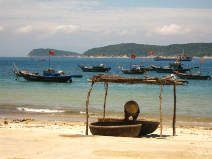
The Island of Cu Lao Cham, facing the harbour of Faifoo was an important stop for the foreign ships. This is where in 1523, Duarte Coelho, planted a “padroes,” to mark the official “discovery” of Cochinchina by the Portuguese. (photo by Charlotte Pham © C.M.H. Pham).
Previous Next