Bach Dang Project Page
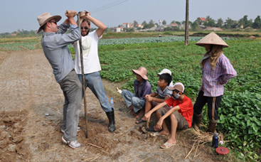
Dave and Doug augering with an audience during the 2011 field season (photo by Mark Staniforth courtesy of the Bach Dang River and Van Don Research Team).
Maritime Archaeology Fieldwork
2008 A preliminary visit to the Bach Dang River area was undertaken by members of the research team, some of whom had backgrounds involving archaeological research on the Yuan Dynasty invasion of Japan or in Southeast Asian maritime archaeology. From this visit an opportunity arose to establish a long-term collaborative project with the Institute of Archaeology (IA) in Hanoi. The aim was to develop an on-going program of maritime archaeological research in Vietnam over the longer term that was initially built on a verbal, and later a written, agreement with IA and specifically included thematic research on naval battlefield archaeology at the Bach Dang River.
Jun Kimura and Jim Delgado at the Yen Giang stakeyard during the 2008 fieldwork season (photo by Mark Staniforth courtesy of the Bach Dang River and Van Don Research Team)
2009 The research team conducted an extensive survey in Quang Yen town and on Ha Nam Island in March 2009. This first phase of fieldwork was focused on establishing the exact location of stake yards using GPS units and a Total Station to develop an interactive GIS of the area. The targeted area of the recording work was in the north-west corner of Ha Nam Island. During the investigation in 2009, inhabitants of Dong Ma Ngua at the south end of the village of Hung Hoc reported the discovery of a wooden stake in one of their fishponds.
In 2009 we were accompanied by Peter M. Ingrassia, a professional cameraman, who was supported by Waite-National Geographic to film our work. Peter posted two 8 minutes videos on Vimeo see:
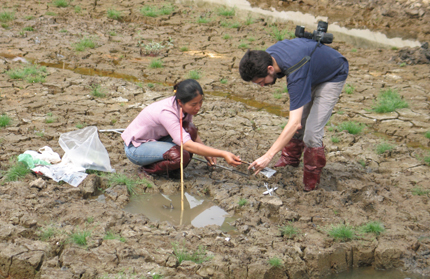
Mai and Randy in the fishpond at Dong Ma Ngua during the 2009 fieldwork season (photo by Le Thi Lien courtesy of the Bach Dang River and Van Don Research Team)
2010 An excavation was formally commissioned by the Management Board for Major sites of Quang Ninh Province which then worked with the Institute of Archaeology and the Research team to open four new trenches that were later integrated into one large trench. Two additional test trenches were opened in the rice fields around the Dong Ma Ngua site to compare the sediments in the surrounding area and to further develop our understanding of the topographical features. A total of 55 stakes were identified in the fishpond at Dong Ma Ngua. We ascertained the stakes’ distribution within the stake yard and recorded detailed features of the stakes. Timber samples were collected from ten stakes found during excavations at Dong Ma Ngua in 2009 and 2010 and these were sent to the Forestry and Forest Products Research Institute in Japan and the Vietnam Forestry University. Samples from four wooden stakes were sent to the University of Waikato Radiocarbon Dating Laboratory. Radiocarbon dating shows relatively close dates to the battle of 1288. The oldest ceramic shards dated to the period of the Tran Dynasty (1225-1400 A.D.), although the ceramics assemblage (a total of 107 pieces) represented a wide temporal range up to the 18th century. The location of the newly discovered stake-yard suggests that the naval battle field was considerably larger than has previously been considered.
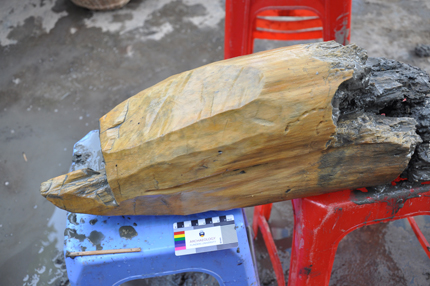
Wooden stake from the 2010 excavation at Dong Ma Ngua (photo by Mark Staniforth courtesy of the Bach Dang River and Van Don Research Team)
2011 An extensive remote sensing survey was carried out specifically to identify the potential location of physical remains of the naval battles, such as ships. An article on the 2011 season at Bach Dang appeared in the INA Quarterly. See:
The Archaeology of Battle - Magnetic survey of Bach Dang in Vietnam. The INA Quarterly. Vol.39. No 1 & 2. pp. 24-27.
http://issuu.com/instituteofnauticalarchaeology/docs/ inaq_vol39nos1_2_2012?mode=window&pageNumber=1
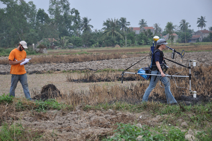
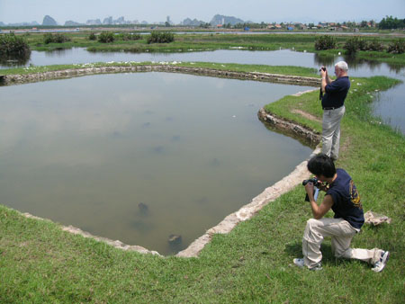
Veronica and Doug conducting a gradiometer survey during the 2011 season (photo by Mark Staniforth courtesy of the Bach Dang River and Van Don Research Team)
2012 From 22 to 26 November 2012 the Research group conducted a short research season including a small excavation in Long Thong at Yen Hai in Hai Yen commune. A trench of 4 m long by 2 m wide was excavated to a maximum depth of 2.4m and coring using a Livingstone corer was conducted. At Hai Yen significant layers of clay on top an oyster shell deposit suggest a tidal marine deposit overlying a marine environment. Below the oyster shell layer lies a meter of organic clay and silt followed by another half meter of dense clay with clear bands of sand, shells and small plant material.
Mark, John, Christy and Jun coring during the 2012 season (photo by Le Thi Lien courtesy of the Bach Dang River and Van Don Research Team)
2013 The international joint research team, with the approval of the Quang Ninh Province Management Board and the cooperation of the Yen Hung district, from 15 to 31 October 2013 conducted a two week research season. Major archaeological activities include trench excavations in Long Thong at Yen Hai in Hai Yen commune and at Yen Giang and magnetic survey in concerned areas.
Based on 2011 remote sensing survey, two trenches for archaeological excavation were selected at Long Thong in an irregularly shaped agricultural field bound by the Hai Yen irrigation ditch, for the 2013 trench excavation. The field measures roughly 120m by 271.7m (2.27 hectares) and has 19 recorded magnetic perturbations distributed mostly in the central and eastern portions of the field. A group of four anomalies (M91, M93 to M95) and one isolated anomaly (M91) appeared to have some potential of being associated with buried heritage material.
Long Thong Trench 1
A trench of 15 m long (E-W) by approximately 5 m wide (N-S) was excavated to a maximum depth of 2.4m on magnetic anomaly M91. A Komatsu excavator was employed to remove a large amount of soils of the upper layers of the trench. It took approximately 6 hours over a two-day periods to complete this operation. A thick oyster layer was located at 1.00m depth. The oyster layer continues through the lower layers. The size of the oyster shells from these layers is extremely large (up to 40cm in length).
Long Thong Trench 2
A trench of 5m long (N-S) by 3m wide (E-W) was excavated to a maximum depth of 2.00m on magnetic anomaly M98 over a five-day period from Sunday 21 October to Friday 25 October 2013. Excavation was conducted in five layers creating “steps” each of which was approximately 30 cm deep and 20cm wide on each of the four sides resulting in a trench that was approximately 40cm shorter and 40 cm narrower at each level. The five workers used a cutting spade and a wire cutter to create blocks of clay/mud that were then removed by hand onto spoil piles next located next to the trench. The oyster layer was located at 2.00m (35 cm thick) and the oyster shells are smaller and the layer is not as thick as in Trench LT 1. A keyhole of 0.5m by 0.5m was cut through the oyster layer to establish the thickness of the layer and to see what was under the oyster layer = silt down for another 1m.
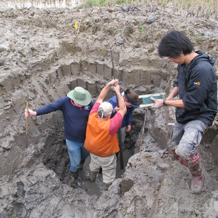
Excavating in Long Thong Trench 2 (photo by Mark Staniforth courtesy of the Bach Dang River and Van Don Research Team)
This was the first time for the research team to conduct archaeological survey and excavation in the area of Yen Giang. The purpose of the survey and excavation was a preliminarily assessment of the potential for the remnants of unidentified cultural objects, taking into the consideration proposed future development of the area. The study areas were carefully selected based on criteria, including archaeological potential, environmental differences, and area accessibility.
Yen Giang Trench 1
Yen Gian Trench 1 was set in a fish pond owned by a private family who possess a large number of fish ponds in the vicinity of the historic site, so-called Bai Coc Bach Dang (Yen Giang Stake Yard). Excavation was conducted based on magnetic anomalies, which were identified in the middle of a fish pond by the marine magnetometer. Water in the pond needed to be removed before conducting excavation and two water pumps were used. While two water pumps effectively functioned to transfer water from the excavation fish pond to adjacent fish ponds, water still constantly flowed into the pond. The wet condition of the bottom of the fish pond made the trench excavation difficult. The five workers barely managed to cut steps in the trench by using a cutting spade and a wire cutter to create blocks of clay/mud. The sediments of this trench were distinctive from the trenches at Long Thong and mostly consisted of mud and sand layers.
Yen Giang Trench 2
A trench of 5m long (N-S) by 3m wide (E-W) was excavated to a maximum depth of 2.30m over a four day period from Friday 25 October to Monday 28 October 2013. Excavation was conducted in five layers creating “steps” each of which was approximately 30 cm deep and 20cm wide on each of the four sides resulting in a trench that was approximately 40cm shorter and 40 cm narrower at each level. The three workers used a cutting spade and a wire cutter to create blocks of clay/mud that were then removed by hand onto spoil piles next located next to the trench.
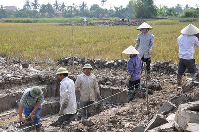
Charlotte during the excavating of Yen Giang Trench 2 (photo by Mark Staniforth courtesy of the Bach Dang River and Van Don Research Team)
Previous Next