East Carolina University 2008 Fall Field School Methodology Gallery
Historic Shoreline becomes Metropolitan Street
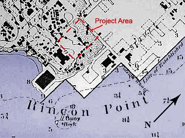
1859 U.S. Coast and Geodetic Survey Map
The northwest corner of the project area was selected for preconstruction controlled excavation and data recovery. The northwest corner is the historic location of the Yerba Buena Cove shoreline, which was filled in as part of the post-Gold Rush urban expansion of San Francisco. By 1887, the filling of the cove had been completed, bringing the elevation of the project parcel to a rough equivalent to what it is today.
Using GIS software, WSA plotted the locations of the original Yerba Buena Cove shoreline, and the structures within the project parcel that are depicted on the 1853 and 1859 U.S. Coast Survey maps.
Based on the projected location of the original shoreline, it was assumed that cultural deposits would be encountered at shallower depths on the east or landward side of the original shoreline and, because of the filling episodes, at deeper levels on the west or cove side.
Previous Next