
East Carolina University 2008 Fall Field School Methodology Gallery

Data Post-Processing
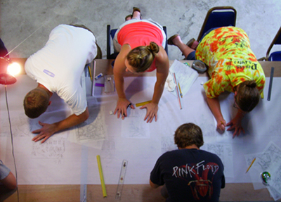
Students at work on the penciled master plan a combination of ten-foot sections recorded underwater (Courtesy Program in Maritime Studies).
Once the wreck has been mapped on individual Mylar sheets, site details can be traced on to a large roll of paper. Because the underwater maps were recorded to scale, they fit together easily. When each piece of Mylar has been traced, the new full-size site map is checked for accuracy and style. Symbols and line weights are standardized, and curves are redrawn with drafting tools, rather than by hand as they were underwater. After the pencil site map is finished it is carefully traced in ink. This allows further standardization of line weights and features, and is one of the final stages of preparing the drawing for publication. Once title, scale, and other textual information are added to the drawing, it is ready to be published.
Previous Next