
East Carolina University 2008 Fall Field School Methodology Gallery

Site Recorder- 3D mapping Program
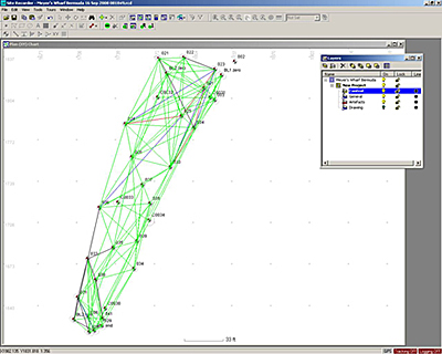
Screenshot of the Site Recorder measurements for Meyers Wharf Site 1, used to determine the accuracy of site plans (Image: David Stewart).
Accurately measuring in three dimensions is often difficult underwater. To help deal with this problem, ECU often employs Site Recorder, a computer based program designed to aid in compiling three-dimensional measurements of archaeological sites. Archaeologists set up a web of fixed points on and around a shipwreck and measure the distance between as many points as possible. The collected data is entered into the program which places points at their exact location in three-dimensional space. The user inputs the degree of tolerable error and the program indicates which measurements do not conform to this level of accuracy. This enables the archaeologists to re-measure problematic points and assists in the creation of a more accurate site plan.
Previous Next