
East Carolina University 2008 Fall Field School Methodology Gallery

Mapping the Wrecks of St. Georges Parish
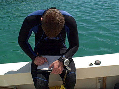
A diver prepares their slate in advance of entering the water to record a ten-foot section of shipwreck debris along a site baseline (Video by Program in Maritime Studies, ECU).
Mapping the wrecks of St. Georges Parish begins with setting up a baseline along the length of the site. Archaeologists are assigned sections along the baseline of a wreck. To record what they see, archaeologists use plastic slates equipped with water-proof film (Mylar). Different techniques may be used to set-up the Mylar depending on the recording methodology, but typically a representation of the baseline is present, along with a measured grid system. This grid system allows the archaeologist to record the wreck to scale using only one or two measuring tapes.
Previous Next